| Tracking the next pandemic: Avian Flu Talk |
NASA,shows climate change cities that will flood |
Post Reply 
|
| Author | |
carbon20 
Moderator 
Joined: April 08 2006 Location: West Australia Status: Offline Points: 65816 |
 Post Options Post Options
 Thanks(0) Thanks(0)
 Quote Quote  Reply Reply
 Topic: NASA,shows climate change cities that will flood Topic: NASA,shows climate change cities that will floodPosted: November 18 2017 at 2:01pm |
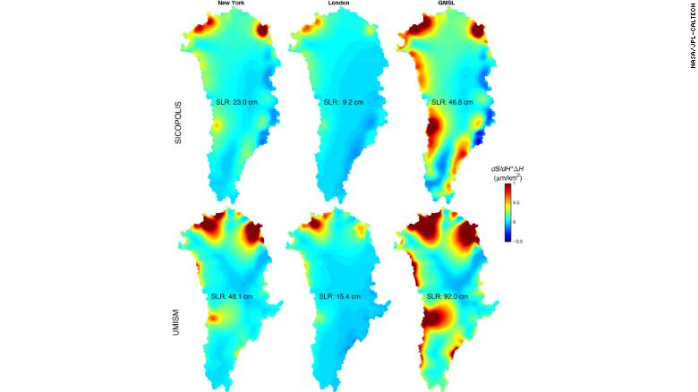
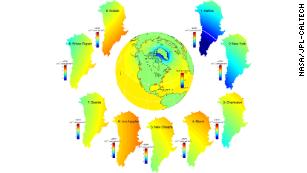
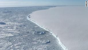
New NASA tool can tell you which glacier may flood your city as the planet warmsBy Brandon Miller, CNN Meteorologist Updated 2127 GMT (0527 HKT) November 16, 2017 (CNN)Sea level rise is one of the most recognizable consequences of climate change and is likely to be one of the most destructive as well. Projecting when destructive coastal inundation could occur in your city just became easier, thanks to a new tool developed by NASA scientists. By pinpointing which specific glaciers and ice sheets are contributing to local sea level rise for individual coastal cities, scientists can paint a more complete and accurate picture of what global warming will mean for rising ocean levels. "This study allows one person to understand which icy areas of the world will contribute most significantly to sea level change (rise or decrease) in their specific city," Eric Larour, one of the study's authors, told CNN. Earlier this month, a major climate report released by the Trump administration revealed that global average sea level has risen by about 7-8 inches since 1900, with almost half of that rise coming in the last 25 years. Projections show that oceans will rise on average by 1-4 feet across the globe by 2100, but the amount of rise will not be uniform for everyone. Understanding how sea level rise will be distributed is a big question facing researchers and planners for major coastal cities worldwide. A key driver of sea level rise is the melting of land ice from ice sheets in Greenland and Antarctica, as well as glaciers worldwide, but tracking how that meltwater influences individual sea levels is no easy task. Researchers at NASA's Jet Propulsion Laboratory have developed a tool that takes into account the rotation of the Earth and gravitational effects, which help to determine how specific melting points will impact certain cities. The research has been published in the journal Science Advances and is available online. The online tool can be a bit technical to use and understand. In the study, the researchers "looked at 293 major port cities to allow coastal planners to readily calculate local seal level change," as well as know which locations of the Earth's polar ice cap melts present the biggest danger to them in particular. For example, comparing the impact that Greenland melting will have for New York City to that of London reveals some interesting insight. While all quadrants of the Greenland ice sheet are melting and contribute to sea level rise all over the world, this study shows that both NYC and London are vulnerable to melt almost exclusively from the northern most parts of the ice sheet, with New York showing contributions from both the northwest and northeast quadrants of Greenland.  Projected contribution of Greenland ice sheet melt to sea level rise in New York City (left column) and London (middle column), compared to contributions to global averaged sea level rise (right column). Londoners, however, need to look primarily at the northwest portion of Greenland, the part of the island farthest from the city itself. While counterintuitive, this result is found repeatedly for cities around the globe: The biggest contributions to local sea level rise come from glaciers and ice sheets farthest away from the city themselves. There is a physical explanation for this -- gravity.  Sensitivity of sea level rise along US/Canada coastline to melt across Greenland. Graphic shows which parts of Greenland most contribute to sea level rise for each city listed. Red colors indicate high contributions while blue colors are low or even negative contributions. "Ice sheets are so heavy, that when they melt, the gravity field is modified, and the ocean is less attracted to the ice mass," Larour said. "This means that locally, close to the ice change itself, sea level will decrease." That could be the case in cities such as Reykjavik, Iceland, or Halifax, Canada. Similarly, the research showed that Sydney, Australia is most affected by the melting of the Antarctic ice sheet on the other side of the Antarctic continent from the eastern Australian city.  Photo from a NASA observation flight over the Larsen C Ice Shelf in late October 2017 While melting land ice anywhere should concern coastal residents as the planet warms, this tool can help focus those concerns and make specific city projections more accurate. "This tool is very useful to understand risk from specific glaciers, and to form a complete picture of how much risk the city is under," Larour said. He said that city officials can follow observations for the glaciers and polar regions likely to have the most impact on their city and use that data to map projected sea level rise. Knowing more precisely how much the ocean will rise by certain dates will help city planners prepare mitigation techniques to deal with coastal inundation. |
|
|
Everything we hear is an opinion, not a fact. Everything we see is a perspective, not the truth.🖖
Marcus Aurelius |
|
 |
|
Post Reply 
|
|
|
Tweet
|
| Forum Jump | Forum Permissions  You cannot post new topics in this forum You cannot reply to topics in this forum You cannot delete your posts in this forum You cannot edit your posts in this forum You cannot create polls in this forum You can vote in polls in this forum |